
Our multi-disciplinary Deccan Team of investigators.
In 2006 our team began an intensive collaborative effort with Indian scientists to search for the KT boundary in sediments between Deccan lava flows (intertrappeans) as well as above and below. We first focused on Deccan Traps in the Krishna-Godavari Basin near Rajahmundry where basalt is quarried exposing one intertrappean unit between lower (phase-2) and upper (phase-3) Deccan traps. At the end of the Cretaceous, Rajahmundry was in a shallow estuarine environment, which presented a chance that marine microfossils could be present. We were successful discovering the first direct link between Deccan Traps and the KTB mass extinction. Within a year two other teams independently discovered planktic foraminifera in intertrappean sediments in central India (Jhilmili, Madhya Pradesh). Other discoveries followed mainly based on analysis of deep wells drilled by India’s Oil and Natural Gas Corporation (ONGC) in the Krishna-Godavari Basin.
These new discoveries and improved age dating have now brought Deccan volcanism to front and center in the mass extinction debate. Increasingly, scientists are recognizing the importance of Deccan volcanism and their global effects are being investigated. Deccan Volcanism is no longer the unspoken elephant in the room, but rapidly emerging as the critical and even most likely cause for the KTB mass extinction. Here we highlight the scientific discoveries by our multi-disciplinary international team of investigators that have revitalized the mass extinction debate and opened the way for new studies across disciplines to evaluate the role of Deccan volcanism in the KTB mass extinction.

Deccan Traps, India
The Deccan volcanic province (DVP) formed during India’s northward migration as it passed over the Reunion hotspot (which is today the Reunion Island). This hotspot is still active today and last erupted on April 7, 2007. The DVP is one of the largest volcanic eruptions in Earth history and today covers an area of 500,000 km2, or about the size of France, or Texas. The original size prior to erosion is estimated to have been at least twice as large. The volume of lava extruded is estimated to have been about 1.2 million km3 and today can be seen in mountains as high as the Alps (~3500 m) (Fig. 1).

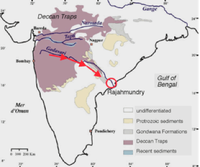
Figure 3. The longest lava flows on Earth are found in the Deccan Traps; they are estimated to flow 1500Km across India and out into the Gulf of Bengal.
The longest lava flows on Earth
Deccan volcanism produced the longest lava mega-flows on Earth, spanning over 1500 km from the main Deccan province across India to Rajahmundry and out into the Gulf of Bengal. Four to five of these longest lava flows occurred just prior to the KTB mass extinction. Another four occurred during the last Deccan eruption phase in the early Danian (Keller et al., 2008; Self et al., 2008). Some of these mega-flows can be observed in Rajahmundry quarries where intertrappean sediments between phase-2 and phase-3 mega-flows are present and have yielded the first evidence of KTB age for phase-2 volcanism (Fig. 4).
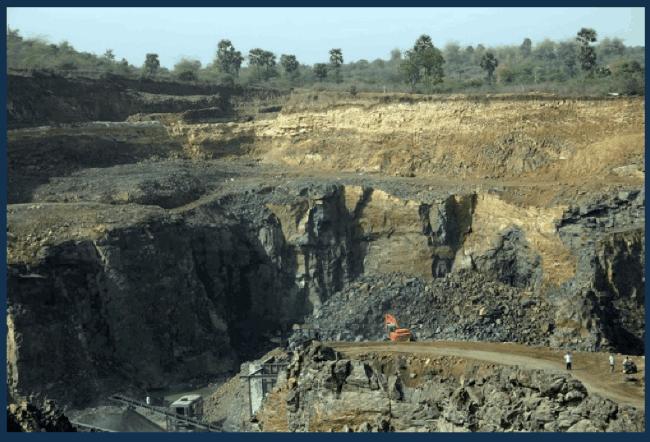
Figure 4. Gauriputnam quarry, Rajahmundry, where volcanic rocks of phase-2 (ended at KTB) and phase-3 (early Danian) can be observed along with the earliest intertrappean sediments.
Three main phases of Deccan eruptions
Recent studies indicate that Deccan volcanic eruptions occurred in three main phases with the initial and smallest Phase-1 at ~67.4 Ma; the relatively short main Phase-2 with ~80% of total Deccan volume ends in C29r below the KT boundary; and the last Phase-3 at the base of C29n in the early Danian (Chenet et al., 2007, 2008, 2009), about 280 ky after the Cretaceous-Tertiary boundary (KTB) mass extinction (Fig. 5).

Figure 5. 39Ar/40Ar and K/Ar dating of the main Deccan province reveals that the main phase of eruptions began during magnetochron C29r and ended at the KTB mass extinction. (modified after Chenet et al., 2007). From Keller et al., 2011.
New Database: 2008-2013
The new database linking the main phase-2 Deccan volcanism directly to the KTB mass extinction comes from various localities and is based on sediments between the longest lava flows (called intertrappean sediments) and from intervals above and below the volcanic sediments (see pdf files of papers in publication list):
- Rajahmundry quarries: five quarries analyzed all show KTB mass extinction directly at the end of phase-2 volcanism (Keller et al., 2008; Malarkodi et al., 2010).
- Jhilmili, Chhindwara, central India: KTB also in intertrappeans above phase-2 volcanism; presence of marine microfossils indicates major seaway existed (Keller et al., 2009a, 2009b).
- Krishna-Godavari Basin: Longest lava flows of Phase-2 and Phase-3 volcanism in deep wells drilled by India’s Oil and Natural Gas Corporation (ONGC). Mass extinction complete by end of Phase-2. (Keller et al., 2011, 2012)
- Meghalaya, northeastern India: one of the world’s most complete KTB sections reveals the environmental effects of Deccan volcanism about 800-1000 km from the main volcanic province (Gertsch et al., 2011).

Figure 6. Localities, outcrops and cores analyzed between 2007 and 2010.


