
Impact Evidence in Texas
Challenging a popular theory requires extraordinary proof. The controversy over the age of the Chicxulub impact led to charges that impact and tsunami disturbance made any age determination based on the impact crater, as well as any sections in Mexico with impact ejecta, unreliable and that real proof had to come from more distant sedimentary sequences (Smit et al., 2004). With this in mind, we turned our focus to the KTB sequences along the Brazos River in Texas located about 1300 km from the Yucatan impact crater. These sections contain the best preserved marine and terrestrial microfossil records of North America in essentially continuous KTB sequences similar to the El Kef stratotype section, but with the added advantage of Chicxulub impact spherules.

Figure 53. Paleogeographic reconstruction of Central and North America with locations Brazos River, Texas, and NE Mexico sections and the Chicxulub impact crater. Paleomap from Blakey, R., NAU Geology website (http://jan.uc.nau.edu).
The Brazos sections were deposited near the entrance to the shallow Western Interior Seaway and experienced only minor tectonic activity during the last 66 My. They differ from the deep-water (outer shelf to upper slope) northeastern Mexico sections mainly by their shallow depositional environment and very high sedimentation rate. They share critical similarities, including the presence of a sandstone complex (also known as event deposit and impact-tsunami) with reworked spherules at the base. This sandstone complex has long been interpreted as KTB impact-tsunami or related deposits and served as the type section for the impact-tsunami interpretation in northeastern Mexico (e.g., Bourgeois et al., 1988; Smit et al., 1992, 1996; Heymann et al., 1998; Schulte et al., 2006). The Brazos sections are the ideal testing ground regarding the age of the Chicxulub impact and its biotic and environmental consequences.
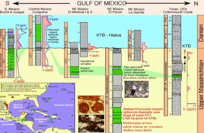
Figure 54. Impact spherule distribution from southern Mexico to Texas. In all but one locality (Coxquihui, Central Mexico) impact spherules are in late Maastrichtian sediments. In Texas these spherules at the base of a sandstone complex in shallow shelf channels provides yet another test case of the age of the Chicxulub impact.
In 2005 we set out to test the challenging results from northeastern Mexico and the Chicxulub crater core Yaxcopoil-1 based on new drilling and KTB outcrops along the Brazos River, Falls County, Texas, supported by the National Science Foundation through the Continental Dynamics Program and Sedimentary Geology and Paleobiology Program. Drilling of Brazos sections Mullinax-1 to Mullinax-3 was done by DOSECC (Drilling, Observations and Sampling of the Earth’s Continental Crust) with each well spanning from the Danian through the Maastrichtian and recovering the KTB interval and the sandstone complex (Fig. 55). In addition, new outcrops exposing the KTB were sampled to obtain a broad regional distribution and sections were studied by an international team of scientists.
We chose the Brazos area for its undisturbed sedimentary record, complete stratigraphic sequences comparable to the El Kef stratotype, absence of significant tectonic activity, excellent preservation of microfossils and the presence of a sandstone complex with impact spherules. In addition, the Brazos River area affords relatively simple and inexpensive coring of only 17-35 m to span the KTB transition and late Maastrichtian. These attributes make the Brazos sections the most important KTB locality outside Mexico and critical to resolving the current controversy regarding the age of the Chicxulub impact and its potential kill effect.

Figure 55. Twelve KTB sequences, including three cores and nine outcrops were analyzed along the Brazos River with the aim of testing the age of the Chicxulub impact and the position of the KTB relative to the impact evidence. From Keller et al., 2011.
Our main objectives of this study: (1) determine the stratigraphy and completeness of the Brazos sections based on high-resolution quantitative planktic foraminiferal biostratigraphy and stable isotope stratigraphy, (2) evaluate the Ir anomaly as a KTB marker in Brazos sections, (3) locate the KTB based on globally accepted identifying criteria, (4) determine the age of the sandstone complex, and (5) determine the age of the Chicxulub impact. We analyzed four cored sites and all known KTB outcrops (a ten). By analyzing this many Brazos sequences, based on the same interdisciplinary approach integrating microfossil biostratigraphy, stable isotope stratigraphy, PGE analysis, and Chicxulub impact ejecta, we hoped to get some answers that could resolve the KTB controversy.
10.1 The Sandstone Complex In Texas
Below the sandstone complex in Mullinax-1 and other wells and sections of the Brazos area, upper Maastrichtian sediments consist of organic-rich dark gray to black, bedded claystones and fissile shales with common macrofossils. Deposition of upper Maastrichtian claystones at Mullinax-1 and Cottonmouth Creek occurred in a middle-neritic environment that shallowed to inner-neritic depths by the time the sandstone complex was deposited, as indicated by macrofossils, benthic foraminifera, and low diversity planktic foraminifera (Keller, 1992; Keller et al., 2007a; Hart et al., 2011).
All Brazos outcrops and wells show very similar lithologies of bedded claystones and mudstones interrupted by a prominent sandstone complex (Fig. 56), also known as the “impact-tsunami deposit” (Bourgeois et al., 1988; Smit et al., 1996; Heymann et al., 1998; Schulte et al., 2006), “event deposit” or “storm deposits” associated with a sea-level lowstand (Keller, l989a; Yancey, 1996; Gale, 2006; Keller et al., 2007a). The only exception is Mullinax-2 and 3, cored side by side and represents the shallowest depositional environment with subaerial erosion correlative with the sandstone complex in other localities (Adatte et al., 2011). In all other sections variations in the sandstone complex between outcrops consist mainly in the overall thickness of units, the number of individual sand layers, the number of upward-fining spherule-rich layers, and the nature and abundance of clasts at the base of the channel deposits. One of the best illustrations of the sandstone complex and its diverse layers is seen in the core from Mullinax-1 (Fig. 57). The lithology, mineralogy and geochemistry of this core were published in Keller et al. (2007a; Adatte et al., 2011).

Figure 56. The sandstone complex at Darting Minnow Creek.
The sandstone complex overlies the scoured surface of submarine channels that mark erosion during a low sea level and the subsequent infilling during the subsequent sea-level rise (Fig. 56). The thickness and lateral extent of the sandstone complex is variable. The thickest exposure (1.0 m) is found in the Darting Minnow Creek, but only about 150 m away in wells Mullinax-2 and 3 there is no trace of the sandstone complex. More commonly the sandstone is about 0.3-0.4 m thick with a similar sequence as in Mullinax-1 (Fig. 57), or reduced to a 10 cm sand layer (e.g., Brazos-2 and -3).
The base of the sandstone complex commonly contains large (5-10 cm) lithified clasts and soft claystone clasts from underlying sediments (Fig. 58A, B). At Mullinax-1 (and KT1-KT2) only soft small claystone clasts are present and the underlying 10 cm of the claystone layers are fractured. However, large clasts are described from the nearby Brazos-1 locality and in Cottonmouth and Darting Minnow Creek outcrops (Fig. 58A, B) (Hansen et al., 1987; Yancey, 1996; Keller et al., 2007, 2011, Adatte et al., 2011).
Above the clasts are two or three upward- fining impact-spherule-rich layers with abundant shell hash, glauconite, and sand. This is followed by one to several hummocky cross-bedded sandstone layers that contain truncated burrows, followed by laminated sand, a short interval (10 cm) of fining-upward sand prior to the resumption of uppermost Maastrichtian claystone deposition. The sandstone complex thus reveals that deposition occurred prior to the KTB and over an extended time period that is inconsistent with tsunami deposition (Gale, 2006; Keller et al., 2007, 2009d).
10.2. Multiple Spherule Layers
In Cottonmouth and Darting Minnow Creek (Fig. 56) outcrops, lithified clasts are common (Fig. 58A, B)and some contain Chicxulub impact spherules, occasionally within mudcracks infilled by spherules (Fig. 58E-H; Adatte et al., 2011). These clasts reveal the history of Chicxulub impact spherules, their deposition in a shallow environment, subaerial exposure during which mudcracks formed and were infilled with impact spherules eroded from a prior fallout deposit, the subsequent lithification (probably as hardground), followed by erosion, transport, and redeposition of clasts at the base of the sandstone complex. These clasts are thus unequivocal evidence that the Chicxulub impact predates the KTB.
Above the erosion surface and rip-up clasts is a coarse, gray-green, poorly sorted, upward-fining sandstone with abundant shell fragments, glauconite, Chicxulub impact spherules, mudstone and phosphatic clasts, and reworked microfossils (Fig. 57). In Mullinax-1 and wells KT1-KT2 there are three upward-fining glauconite and spherule-rich units topped with fine sandstone, and two such units are observed at the Cottonmouth Creek waterfall outcrop. These discrete layers mark separate depositional events, possibly related to storms. Tsunami deposition can be ruled out by the burrowing, upward fining units and multiple spherule layers.
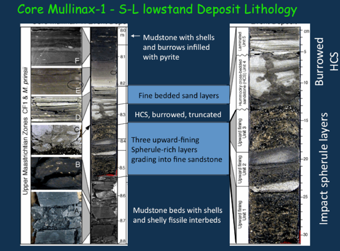
Figure 57. At the Mullinax-1 core the sandstone complex infills a shallow shelf channel. At the base are three impact spherule layers separated by thin sand layers. Above is a hummocky cross-bedded sandstone (HCS) burrowed with the burrows truncated at the top and bottom. Laminated fine sand and shale layers mark the top followed by upward fining grain size.

Figure 58. Cottonmouth Creek (CM) sequence described in Adatte et al., 2011. Large lithified clasts are present at the base of the sandstone complex at the CMC section and Darting Minnow Creek (DMC) and some of the clasts contain impact spherules and mudcracks infilled with impact spherules. From Adatte et al., 2011).
Each of the spherule-rich layers contains nearly 100% cheto Mg-smectite, which is derived from altered glass (Adatte et al., 2011). A 3-cm-thick yellow clay layer, 45-60 cm below the sandstone complex at the Cottonmouth Creek waterfall section contains the same cheto smectite (Fig. 58), which can be traced over 20-30 m depending on outcrop exposures. Because the yellow clay and the two impact spherule-rich layers have the same Mg-smectite of altered glass, and no volcanic minerals were detected in the yellow clay (Fig. 58, 59), Keller et al. (2007, 2011) and Adatte et al. (2011) erroneously interpreted the yellow clay as altered impact glass. Recently, rare sanidine crystals were discovered in this yellow clay, which indicates a volcanic origin (Hart et al., 2012). During spring flooding a new outcrop was exposed along the riverbank with a similar clay layer about 1.5 km upriver, though no sandstone complex is present and the age of this clay layer is uncertain.

Figure 59. Cottonmouth Creek outcrop showing the sandstone complex with impact spherule layers and 45-60 cm below a yellow clay layer. The KTB is about 4.2 m above the yellow clay.
10.3. Burrows in Sandstone Complex
In most outcrops and wells, the spherule-rich sandstone underlies one or more hummocky cross-bedded sandstone (HCS) layers that are strongly burrowed and truncated at the top and bottom (Figs. 57, 60). Burrows are identified as belonging to Ophiomorpha nodosa, Thalassinoides sp., Planolites sp. (Fig. 60; Gale, 2005; Keller et al., 2007). These HCS layers are likely tempestites. The overlying laminated silty mudstone with small burrows indicates decreased energy. A calcareous silty claystone marks the top of the sandstone complex, with upward fining grain size limited to 10-15 cm and Ca decreasing from 60% to 10%. The return to normal sedimentation is marked by dark bioturbated organic-rich claystone with burrows commonly infilled with framboidal pyrite indicating hypoxic conditions. This low-oxygen environment prevailed throughout the 1 m interval between the top of the sandstone complex and the KT boundary. There is no lithological change across the KTB, except for the gradually more calcareous and lighter gray silty claystones in the lower Danian.
The burrows in the sandstone complex rule out impact-tsunami deposition. The multiple burrowed horizons documented by Gale (2005) suggest seasonal storms with rapid influx of sand burying the burrowed surface, followed by recolonization. This is similar to the multiple horizons of trace fossils in NE Mexico that Ekdale and Stinnesbeck (1998) documented.

Figure 60. Illustration of the sandstone complex with tiered layers of burrowed horizons interpreted as multiple tempestites (Gale, 2005).
10.4. Normal Sedimentation – No Evidence of Tsunami
Brazos sections and cores reveal normal marine sedimentation from the late Maastrichtian across the sandstone complex and the KTB as shown for Cottonmouth Creek and Mullinax-1 (Fig. 61). Carbon isotopes of fine fraction and benthic foraminifera show major negative shifts in the thin yellow and grey clay layers (bentonite), and the sandstone complex, which likely reflect diagenetic alteration. In the claystones above the sandstone complex normal d13C values are restored and then gradually decrease reaching lowest values just above the KTB. Cheto smectite in both localities mark the altered glass of the spherule layers in the sandstone complex, and the same signal is present in the yellow clay altered bentonite. There is no sedimentary evidence of major disturbance at the KTB and no clay layer or Ir anomaly.
Thus Mineralogic and geochemical data clearly show the same sediment composition below and above the sandstone complex, which indicates that the sandstone complex was deposited during the latest Maastrichtian zone CF1. The sedimentologic characteristics of the sandstone complex, e.g., burrowed horizons, truncated burrows, multiple spherule layers, lithified clasts with impact spherules, indicate erosion, transport and re-deposition, during a sea level fall. Further evidence for a pre-KTB age of the sandstone complex comes from planktic foraminiferal assemblages and the mass extinction.

Figure 61. Mineralogic, geochemical and granulometric data across the sandstone complex and KTB in Cottonmouth Creek and Mullinax-1 reveal normal marine sedimentation patterns. The KTB is marked by the negative d13C shift and faunal and floral turnovers. Cheto smetite is present in the yellow clay and impact spherule layers. From Keller et al., 2007.
10.5. KTB in Texas – No Impact Evidence
The Cretaceous-Tertiary boundary (KTB) sequences along the Brazos River, Texas, U.S.A., have been controversial for over two decades. At issue is whether the KTB and the mass extinction should be placed at the base of a sandstone complex based on the presence of Chicxulub impact spherules or at the mass extinction. This issue goes to the very core of the KTB controversy – did the Chicxulub impact cause the KTB mass extinction?
Placement of the KT boundary
The KTB is one of the most extensively documented stratigraphic intervals in marine environments based on lithologic, paleontologic, and geochemical markers. Originally proposed for the El Kef stratotype, these markers include: (1) a dark organic-rich boundary clay with a 3-4 mm thin oxidized red layer at the base, (2) an iridium anomaly largely concentrated in the red layer, (3) the mass extinction of all tropical and subtropical planktic foraminiferal species, (4) the first appearance of Danian species within a few centimeters above the extinction horizon, and (5) a 2-3‰ negative shift in d13C values of marine carbonate (Keller et al., l995; Keller et al., 2002; Remane et al., 1999). These KTB identifying criteria have remained remarkably consistent in hundreds of marine sequences analyzed worldwide, although the Ir anomaly and the clay layer may not be present and no Chicxulub impact spherules are present at the KTB where this boundary has a complete record. No Ir anomaly or impact spherules are present at the KTB in the Brazos River sections.
Controversy and Circular Reasoning:
Despite the global evidence for the placement of the KTB, its placement in the Brazos River sections has been controversial since the late 1980s when the impact hypothesis gained widespread acceptance. That belief led to a strong conviction that the Chicxulub impact caused the KTB mass extinction and therefore any impact signal must define the KTB (see also sections on Mexico, Haiti, impact crater core Yaxcopoil-1). By this reasoning, the sandstone complex with its impact spherules in the Brazos sections represents an impact-generated tsunami deposit and therefore must be the KTB (Bourgeois et al., 1988; Hansen et al., 1987, 1993a; Smit et al., 1996; Heymann et al., 1998; Schulte et al., 2006, 2008, 2010). This has resulted in circular reasoning – the Chicxulub impact is KT in age, therefore the impact defines the KT boundary (see Schulte et al., 2008 and reply by Keller et al., 2008).
This circular reasoning inadvertently gained support when Gradstein et al. (2004) proposed to reduce KTB-defining criteria to just the “Ir anomaly associated with a major extinction horizon”, and Molina et al. (2006) proposed to include any Chicxulub impact markers as KTB-defining criteria (e.g., Ir, spherules, shocked quartz, tsunami deposits, breccia). The inadvertent effect has been the elevation of any impact signal to a key defining KTB criterion. In a recent article by a consortium of scientists, this reasoning was the basis for asserting that the Chicxulub impact is KTB in age and the sole cause for the mass extinction (Schulte et al., 2010).
A scientists Dream – or Nightmare?
This ‘impact stratigraphy’ seemed like a scientist’s dream come true. A global instantaneous event leaves a unique signal worldwide that can now be traced and used as an age marker with absolute certainty - or can it? Like any other sediment markers, impact signals, including Ir anomalies and impact spherules are subject to erosion, reworking, and redeposition (see review by Keller, 2008 on impact stratigraphy). For example, the most widespread and prominent Chicxulub ejecta, the impact-glass spherules, are documented from the Danian in Guatemala, Belize, Haiti, Cuba, southern Mexico, Caribbean and N. Atlantic (Keller et al., 2001, 2003a, b, 2013; Keller, 2012), but all have been interpreted as KTB age by various investigators (Norris et al., 1999, 2000; Arenillas et al., 2006; MacLeod et al., 2007). Similarly, impact spherules from the upper Maastrichtian sandstone complex in northeastern Mexico and Texas (Keller et al., 2003a, 2007a), and from still older upper Maastrichtian sediments in northeastern Mexico and Texas (Keller et al., 2007a, 2009a, b) are interpreted as KTB age (e.g., Smit et al., 1993, 1996; Schulte et al., 2006, 2008, 2010).
Where should the KT boundary be placed based on these variable stratigraphic occurrences of impact spherules? At the base of the spherule layer, as in Blake Nose and Demerara Rise? Or at the base of the sandstone complex with impact spherules in northeastern Mexico and the Brazos River sections of Texas? Or at the stratigraphically still older impact glass spherule layer below the sandstone complex? Clearly, Chicxulub impact spherules (or impact breccia) are not a KTB-defining marker horizon, nor are the variable occurrences of small Ir anomalies. In fact, based on the law of superposition, the stratigraphically oldest Chicxulub impact-glass spherule layer dates this impact as older than the KT boundary (see review by Keller, 2008). Impact markers are useful in stratigraphy, but they must be used with caution and in corroboration with other independent age markers rather than in isolation.
Rather than a scientists dream, this “one size fits all” interpretation of impact signals as KTB markers has subverted and suppressed scientific investigations, ignored evidence that contradicts the impact hypothesis and fueled the continuing acrimonious controversy – the Dream turned into Nightmare. It is time to return to the time tested scientific principles of geology and paleontology.
10.5. The Mass Extinction in Texas
Investigation of a dozen KTB sections from cores and outcrops along the Brazos River and its tributaries reveal the sandstone complex separated from the KT boundary by up to 1.5 m of claystones (1.6 m reported by Schulte et al., 2006). Mineralogic and geochemical data (Fig. 61) clearly show the same sediment composition below and above the sandstone complex, which indicates that the sandstone complex predates the KTB. Biostratigraphy (planktic foraminifera and nannofossils) show that deposition occurred during the latest Maastrichtian zone CF1 and M. prinsii zone. Stable isotopes in the interval between the sandstone complex and the KTB stable isotopes show the same values as below the sandstone complex followed by gradual decrease and then rapid decrease near the KTB followed by lowest values in the basal Danian (Figs. 62, 63, 64, 65). Sediments are strongly burrowed below and above the sandstone complex, which indicates normal sedimentation with the ocean floor colonized by organisms (Keller et al., 2007, 2011).
Gradual Extinction Pattern
Those who are looking for the deep-sea mass extinction pattern in the Brazos River sections will find similarities, but also significant differences by virtue of its shallow marine environment. During the late Maastrichtian, sediment deposition occurred in a middle-neritic environment that rapidly shallowed to inner-neritic depth by about the middle of zone CF1, culminating in scoured channels (incised valleys) that were infilled by the sandstone complex during the early transgression (Gale, 2006; Keller et al., 2007a, 2011; Adatte et al., 2011). The mass-extinction pattern mirrors this shallow shelf environment and drop in sea level below critical depth sustaining diverse assemblages.
Open Marine: In contrast, deeper open marine middle to outer shelf sections in Tunisia and elsewhere contain diverse assemblages (Keller et al., 1995; Keller et al., 2002; Abramovich and Keller, 2002; Keller et al., 2002; Stüben et al., 2002). Abramovich and Keller (2002) identified a total of 63 planktic foraminiferal species in the late Maastrichtian of Elles. Over 2/3 of these species go extinct at or before the KT boundary marking an abrupt extinction level (Fig. 62). Survivors continue well above the KTB, although they are generally dwarfed indicating high stress conditions. The evolution of new species follows the same pattern worldwide in open marine and shallow neritic environments. All evolving species are very small, frequently <63mm, have simple morphologies, small globular chambers with thin wall and lack ornamentation. These characteristic mark the global post-KTB high stress environment (Keller, 2011).
During the latest Maastrichtian reductions in species diversity correlate with climate warming in zone CF1 and decreased productivity. In this interval, species dwarfing and increased abundance of the disaster opportunist Guembelitria cretacea mark non-optimum or high-stress ecologic conditions leading to rare or sporadic occurrences and shortened species ranges, also known as the Signor-Lipps effect (Signor and Lipps, 1982). In contrast, the end-Maastrichtian cooling and increased productivity correlates with a marked increase in species richness (Keller, 2011).

Figure 62. The mass extinction pattern in the open marine environment at Elles, Tunisia. Note the species diversity is twice as high as in shallow water environments (see Pardo and Keller, 2008).
The increase is predominantly in the more specialized larger species which go extinct at or before the KTB. Survivor species and evolutions remain the same or similar.
Shallow Shelf: In contrast to open marine, the shallow shelf environment of Brazos and elsewhere has very low species diversity because all large ornate species living in deeper waters are excluded and other species disappear gradually below the KTB (Fig. 63) (e.g., Denmark, Tunisia, Bulgaria, Egypt, India, Mexico, Argentina, Brazil, Keller et al., 1993,1998, 2002, 2007, 2008, 2009; Keller, 2002, 2011; Adatte et al., 2005; Pardo et al., 2013). As a result, the mass extinction pattern is gradual or progressive compared with patterns from open-ocean environments (Fig. 62). Four Brazos localities in outcrops and cores (Figs. 63-66) demonstrate that this pattern is largely the result of the inner-neritic depositional settings coupled with global cooling and the sea-level fall that culminated with deposition of the sandstone complex (Adatte et al., 2011).
At the Cottonmouth Creek section and the classic Brazos-1 locality on the bank of the Brazos River near the highway bridge the extinction pattern is gradual beginning below the sandstone complex and continuing 5-10 cm above the KTB. The KTB is identified by the mass extinction, the first appearance of evolving new species and the d13C shift (Figs. 63-66). No KTB Ir anomaly is present in any of the sections analyzed and no clay layer or red layer is present. The reason is likely the high sedimentation rate and influx of terrigenous sediments preventing clay accumulation during the sea level high and flooding surface that marks the KTB worldwide (Gertsch et al., 2011).
The KTB is always above the sandstone complex, although the thickness of sediments between the KTB and the top of the sandstone complex is variable. In Cottonmouth Creek sections the thickness is generally less than 65 cm, whereas near the highway bridge it varies from 100-150 cm (Figs. 63, 64, 65, 66). The difference is likely due to distance from shoreline and topographic variations in the seafloor. Beyond these differences, the planktic foraminiferal biostratigraphy, faunal assemblages and species abundances are remarkable similar indicating the same high stress conditions.
The gradual extinction pattern beginning below the sandstone complex is due to the sea-level regression and shallowing environment from middle to inner neritic depths. This shallowing is indicated by the abrupt increase in shallow benthic species at the base of the sandstone complex coincident with global cooling (Fig. 65). Paleodepth of the Brazos sections was variable due to topographic variations and distance from shore. At the time the sandstone complex was deposited, paleodepth varied probably between maximum 30-50 m to just a few meters as indicated in the Mullinax-2/3 cores where roots indicate the presence of mangroves (Adate et al., 2011).

Figure 63. Brazos Cottonmouth Creek section: relative abundances and species ranges of planktic foraminifera going extinct, surviving, newly evolving species and stable isotopes. From Keller et al., 2009, 2011.
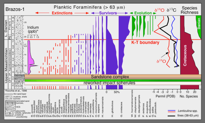
Figure 64. The classic Brazos-1 section on the bank of the Brazos River near the highway bridge. Re-examination of this section revealed the KTB mass extinction and negative d13C excursion about 1 m above the sandstone complex. The Ir anomaly, the largest in the Brazos sections, has the maximum concentration in a thin red sandy clay layer (redox layer) and decreasing abundance to background levels over the 20cm above.

Figure 65. The Mullinax-1 well showing relative abundances and species ranges of planktic foraminifera going extinct, surviving, newly evolving species and stable isotopes. From Keller, 2011. Note the sea level drop indicated by decreased planktic species richness and increased shallow benthic species coincident with major cooling at the time of deposition of the sandstone complex.

Figure 66. Brazos wells KT1-KT2: Relative abundances and species ranges of planktic foraminifera going extinct, surviving and the newly evolving species. Species richness, percent planktic/benthic species and stable isotope provide environmental information. From Keller, 2011.
K-T Transition above the Sandstone Complex
The four species abundance and range illustrations (Fig. 63, 64, 65, 66) show that Foraminifera are of significantly lower diversity (15-20 species) and generally very small, dwarfed size above the sandstone complex (MacLeod et al., 2000; Keller and Abramovich, 2009). These assemblages indicate a high-stress inner-neritic environment after the sea-level fall and gradually increasing across the KTB and into the early Danian. There is no evidence of a major hiatus at the KTB in Brazos sections, except in the Darting Minnow Creek area, where the uppermost Maastrichtian and the lower part of zone Pla (subzone P1a(1) are missing at a major unconformity because this area was much shallower and even subaerial at times. In all Brazos sections, an unconformity and a sea-level drop occurred at the zone P1a/P1b boundary and may indicate a sequence or parasequence boundary (Keller et al., 2011).
Impact-Tsunami Interpretation and KTB Placement
The mass extinction at Brazos is frequently identified as occurring at the base of the sandstone complex, primarily based on the presence of impact spherules, but also the reduction in diversity, abundance and size of microfossils, and near absence of macrofossils above. These low-diversity Maastrichtian assemblages above the sandstone complex are assumed to be due to selective settling from the water column after the tsunami event in the post-impact catastrophe (Hansen et al., 1987; Smit et al., 1996; Schulte et al., 2006; Schulte et al., 2008). This interpretation fails to take into account that settling from the water column can be demonstrated only for the first 10-20 cm above the sandstone complex and not for the entire 80-100 cm interval up to the KT boundary in Mullinax-1, KT1, and Brazos-1 sections (Keller et al., 2007a; Keller et al., 2009, 2011; Adatte et al., 2011). The common and selective occurrence of Cretaceous species in this interval along with Cretaceous carbon isotope signals and absence of Danian species clearly indicates that deposition occurred during the uppermost Maastrichtian, albeit in a high-stress environment (see Keller, 2011). In this interval organic-rich dark claystones with burrows frequently infilled by pyrite and the presence of pyrite framboids indicate deposition in a quiet, nutrient-rich, and possibly eutrophic, low-oxygen environment.
10.6. Iridium Anomaly and Sandstone Complex in Texas
In the Brazos River KTB sections, no lithologic change, no Ir anomaly and no impact spherules are present. Moreover, the KTB is consistently above the sandstone complex by up to 1.5 m (Figs. 63-66). As noted in section 10.5, the absence of a KTB clay layer can be explained by the high sediment accumulation due to high terrigenous influx in this nearshore environment. The consistent stratigraphic position of the KTB above the sandstone complex, and the evidence that rules out a tsunami interpretation for this complex (see sections 10.1. to 10.4.) supports the pre-KTB age of this complex correlative with the sea level fall.
The position and size of the Ir anomaly in the Brazos sections is problematic for the impact-mass extinction hypothesis as well as for using this marker as identifying criterion for the KT boundary. No Brazos sections show an Ir anomaly at the KTB. The Ir anomalies are generally very small (<0.5 pbb), except for the Brazos-1 locality, and always below the KTB (Figs. 63-66). This means that the Ir anomaly is not related to the KTB or the sandstone complex.
Two transects of sections analyzed – transect-1 near the highway bridge over the Brazos River, and transcet-2 about 2 km to the south - show the KTB placement based on standard global criteria and the stratigraphic positions of the sandstone complex and Ir anomalies (Figs. 67, 68). Note that the Ir anomaly and sandstone complex are always well below the KTB. The highest Ir concentrations are in a thin sandy claystones at Brazos-1 about 20 cm above the sandstone complex, and at the nearby Mullinax-1 core in the claystone layers above the sandstone complex (Gertsch et al., 2011). In the old wells KT1-KT2, drilled at the same location as Mullinax-1, only small concentrations are detected (0.3 ppb, Fig. 67). In transect-2 where reduced sedimentation and reduced sandstone complex are present, the Ir anomaly is always <0.5 ppb and immediately overlies the top sand layer, except for the CMAW section where minor concentrations are found below and above the sandstone complex (Fig. 68). All of these Ir anomalies appear to be remobilized and concentrated at redox layers (Gertsch et al., 2011).
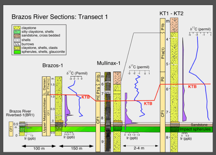
Figure 67. Correlation of the Brazos River sections (transect 1) shows very similar thickness of the sandstone complex and a large interval (up to 1.5 m) of uppermost Maastrichtian sediments between the sandstone complex and the KTB. Note that the KTB is marked by independent KTB-defining criteria (extinction, evolution) and the d13C shift, a global KTB-supporting criterion. The Ir anomaly is well below the KTB (Keller 2011; Gertsch et al., 2011).

Figure 68. Correlation of transect 2, Cottonmouth Creek sections, shows decreasing thickness of the sandstone complex from the waterfall to the Brazos River. In all sections the KTB is above the sandstone complex and elevated Ir concentrations occur in the interval above the latter. The thickness of the claystone between the KTB and top of sandstone complex is reduced compared with transect-1 to the north. This is likely due to the shallower depositional environment and increased erosion towards the south (From Keller et al., 2011).
The Cretaceous–Tertiary Mass Extinction: Theories and Controversies
 SEPM Special Publication No.100, 2011, The end-Cretaceous mass extinction and the Chicxulub impact in Texas. Keller, G. and Adatte, T. (eds).
CHECK THE SEPM WEBSITE FOR AVAILABLITY: SEPM Special Publications

The Cretaceous–Tertiary boundary (KTB) mass extinction is primarily known for the demise of the dinosaurs, the Chicxulub impact, and the frequently rancorous thirty-years-old controversy over the cause of this mass extinction. Since 1980 the impact hypothesis has steadily gained support, which culminated in 1990 with the discovery of the Chicxulub crater on Yucata´n claimed as the KTB impact site and ‘‘smoking gun’’ that virtually proved this hypothesis. In a perverse twist of fate, this discovery also began the decline of the impact hypothesis, because for the first time it could be tested directly based on the impact crater and impact ejecta in sediments throughout the Caribbean, Central America, and North America. Two decades of multidisciplinary studies amassed a database with a sum total that overwhelmingly reveals the Chicxulub impact as predating the KTB mass extinction in the impact-crater cores, in sections throughout northeastern Mexico and in Brazos River sections of Texas, U.S.A. This paper recounts the highlights of the KTB controversy, the discovery of facts inconsistent with the impact hypothesis, and the resurgence of the Deccan volcanism hypothesis as the most likely cause for the mass extinction.
DOWNLOAD CONTENTS AND ABSTRACTS


